Amboise, France to Omaha Beach, France ~ 4 hours
On Saturday morning, we woke up not too early, grabbed some breakfast and hit the road for Normandy around 8:30. After a bit of a misdirection snafu, we were flying along the Autoroute in no time. It was the same as the drive to Amboise, no traffic and wheat fields as far as the eye could see. Once we got into Normandy, we started seeing many more cows (Normandy is known for their cows and dairy products) and as we got closer to the coast we started to see apple orchards (Normandy is also known for their orchards and apple products including cider and apple brandy).

Cows!
We made great time and before we knew it we could see the bright blue waters of the English Channel ahead of us. Just like home! We headed towards Pointe du Hoc, the cliff that the Army Rangers scaled to dismantle the big German guns, and on the way we saw a sign for the German War Cemetery. We had heard that this was a very interesting stop, so we made a quick detour on our way to Pointe du Hoc. The cemetery is kept by a German group who keeps all German war cemeteries abroad. It was very interesting b/c this group believes that by keeping these cemeteries and bringing young people to see the effects of war, hopefully future wars can be prevented. I hope that they are right. This cemetery is very different from the American one, which I had visited on my last trip to France. It is much less ornate and fancy and there were hardly any visitors at all. Even though Germany was the aggressor, the individual soldiers had very little to do with policy-making and war decisions, and it is sad that so few people come to their graves.

Signposts that have maps of the D-Day sights on them

The memorial at the German cemetery

Overlooking the German cemetery
After visiting the cemetery, we continued on the road to Pointe du Hoc. Here they give you the history of the Army Rangers during the D-Day assault and then you can go out onto the point and see what is left of it. There are still the gun placements and the bunkers that the Germans built and most striking are the craters from the Allied bombings. The entire point is dimpled like a golf ball, no level ground anywhere. To get around you walk on the paths formed on the high ground between craters. From the point, you had a view of Utah Beach to the left and Omaha Beach to the right, the two American landing sectors. It must have been unimaginable on that point on D-Day. On a clear day, you'd be able to see the Allied fleet approaching for quite a while, and then the beach had a long run up to the cliffs. If you were on the point, you'd be able to see the entire battle unfolding.

The craters from the bombings

One of the bunkers you can check out

Crooked picture of the Memorial

The pier at Omaha Beach

Janda standing in the dunes

Going for a dip
Just up on the bluffs over Omaha Beach is the American War Cemetery. We arrived there at about the same time as a tour group that included a veteran who had landed at Utah Beach. A group of young men, who may or may not have been military, gathered around him and had their photo taken. I can only imagine how emotional the day was for him. We checked out the monument at the head of the cemetery and then we walked its full length. It is amazing to see how many graves are there. We walked back along the cliffs and then headed into the visitor's center. We didn't have time to see everything b/c it was closing time, but it included several videos and a detailed timeline of the events leading up to, on and after D-Day. They had a lot of personal stories and mementos displayed, very similar to the German cemetery.

Memorial at the American cemetery

Rows of grave markers

Single grave
We continued east and made our last stop of the day at Arromanches, where the Canadians landed at Juno Beach. You can still the the remnants of the artificial harbor and floating bridge that were built there to bring Allied troops and supplies onto the continent. It is a very cute little town, kind of reminiscent of Rockport. There is a pedestrian area right next to the water that is full of cafes, restaurants and shops. After walking the length of the beach, we decided to have dinner here. We got paninis from a small sandwich shop and then ate them down by the water. After dinner, we checked out the weapon displays outside the museum and climbed up to the bluffs above Juno Beach. Another amazing view. On our way out of town, we had another delicious Nutella crepe and then headed to our hotel in Caen.

Downtown Arromanches

The remnants of the bridge and the breakwater in the distance

Looking down at Juno Beach

Overlooking Arromanches

Cows!
We made great time and before we knew it we could see the bright blue waters of the English Channel ahead of us. Just like home! We headed towards Pointe du Hoc, the cliff that the Army Rangers scaled to dismantle the big German guns, and on the way we saw a sign for the German War Cemetery. We had heard that this was a very interesting stop, so we made a quick detour on our way to Pointe du Hoc. The cemetery is kept by a German group who keeps all German war cemeteries abroad. It was very interesting b/c this group believes that by keeping these cemeteries and bringing young people to see the effects of war, hopefully future wars can be prevented. I hope that they are right. This cemetery is very different from the American one, which I had visited on my last trip to France. It is much less ornate and fancy and there were hardly any visitors at all. Even though Germany was the aggressor, the individual soldiers had very little to do with policy-making and war decisions, and it is sad that so few people come to their graves.

Signposts that have maps of the D-Day sights on them

The memorial at the German cemetery

Overlooking the German cemetery
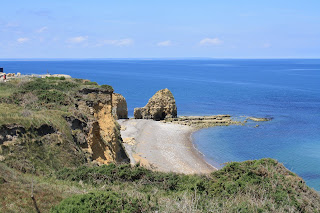
After visiting the cemetery, we continued on the road to Pointe du Hoc. Here they give you the history of the Army Rangers during the D-Day assault and then you can go out onto the point and see what is left of it. There are still the gun placements and the bunkers that the Germans built and most striking are the craters from the Allied bombings. The entire point is dimpled like a golf ball, no level ground anywhere. To get around you walk on the paths formed on the high ground between craters. From the point, you had a view of Utah Beach to the left and Omaha Beach to the right, the two American landing sectors. It must have been unimaginable on that point on D-Day. On a clear day, you'd be able to see the Allied fleet approaching for quite a while, and then the beach had a long run up to the cliffs. If you were on the point, you'd be able to see the entire battle unfolding.

Cliffs and view from Pointe du Hoc

The craters from the bombings

One of the bunkers you can check out
We continued eastward to Omaha Beach. On the westmost edge of the beach there is a war memorial and there are signs along the beaches that tell you which group landed on which beach. When we arrived, it was low tide and the beach was enormous, it looked like a 75m-100m distance from the cliffs to the water. We climbed up to an old bunker and you could see along the whole beach. We drove down to the eastern edge of Omaha, where Easy company landed if you've seen Band of Brothers, and saw the road that the Allies built to bring in supplies from the artificial harbor that they built. As we drove along the beach, we could hardly believe that a mere 60 years ago a battle was raging in Normandy b/c now it looks just like any coastal town in Massachusetts- houses on the ocean, tourists at the beach, little concession stands and shops. It was pretty hot that day, so Janda took a dip in the Channel before we left Omaha Beach.


The pier at Omaha Beach

Janda standing in the dunes

Going for a dip

Memorial at the American cemetery

Rows of grave markers

Single grave
We continued east and made our last stop of the day at Arromanches, where the Canadians landed at Juno Beach. You can still the the remnants of the artificial harbor and floating bridge that were built there to bring Allied troops and supplies onto the continent. It is a very cute little town, kind of reminiscent of Rockport. There is a pedestrian area right next to the water that is full of cafes, restaurants and shops. After walking the length of the beach, we decided to have dinner here. We got paninis from a small sandwich shop and then ate them down by the water. After dinner, we checked out the weapon displays outside the museum and climbed up to the bluffs above Juno Beach. Another amazing view. On our way out of town, we had another delicious Nutella crepe and then headed to our hotel in Caen.

Downtown Arromanches

The remnants of the bridge and the breakwater in the distance

Looking down at Juno Beach

Overlooking Arromanches
No comments:
Post a Comment